Geolocate

Neu-Ulm topographic map

Click on the map to display elevation.

About this map

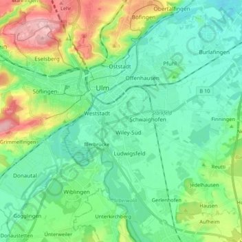
Name: Neu-Ulm topographic map, elevation, terrain.

Location: Neu-Ulm, Landkreis Neu-Ulm, Bavaria, Germany (48.33103 9.96743 48.43350 10.13160)

Average elevation: 1,634 ft

Minimum elevation: 1,480 ft

Maximum elevation: 2,054 ft

Gear up for your next adventure:

🧤Hiking Gloves - Protective gloves for rugged trails
📻Weather Alert Radios - Stay informed of storm risks while off-the-grid
🎒Trail Energy Bars - High‑calorie bars for hiking energy
🔌Solar Panel Charger - Charge gear sustainably outdoors
🏕️Tent Footprint - Protect your tent base from wear

As an Amazon Associate, this site earns from qualifying purchases at no extra cost to you.