Geolocate

Miraj topographic map

Click on the map to display elevation.

About this map

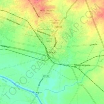
Name: Miraj topographic map, elevation, terrain.

Location: Miraj, Sangli District, Maharashtra, 416400, India (16.77903 74.60324 16.85903 74.68324)

Average elevation: 1,821 ft

Minimum elevation: 1,739 ft

Maximum elevation: 1,939 ft

Gear up for your next adventure:

🛠️Outdoor Gear Repair Kit - Essential tools to fix gear on the trail
📡GPS Antenna Upgrade - Enhance GPS reception in remote terrain
🛌Ultralight Sleeping Bags - Compact down bags for cold nights in the wilderness
🪶Wildlife Field Guides - Learn animal tracking and species ID
🪑Portable Camp Table - Compact table for campsite meals

As an Amazon Associate, this site earns from qualifying purchases at no extra cost to you.