
Mead topographic map
Interactive map
Click on the map to display elevation.
About this map
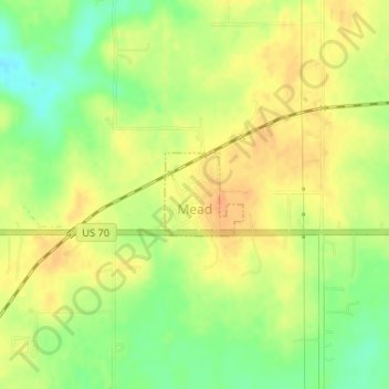
Name: Mead topographic map, elevation, terrain.
Location: Mead, Bryan County, Oklahoma, United States (33.99789 -96.51363 34.00370 -96.50704)
Average elevation: 735 ft
Minimum elevation: 666 ft
Maximum elevation: 781 ft
Other topographic maps
Click on a map to view its topography, its elevation and its terrain.
Achille
United States > Oklahoma > Bryan County
Achille, Bryan County, Oklahoma, United States
Average elevation: 640 ft
Durant
United States > Oklahoma > Bryan County
Durant, Bryan County, Oklahoma, 74701, United States
Average elevation: 669 ft
Kemp
United States > Oklahoma > Bryan County
Kemp, Bryan County, Oklahoma, 74747, United States
Average elevation: 627 ft