
Make a donation
Gear up for your next adventure:
As an Amazon Associate, this site earns from qualifying purchases at no extra cost to you.
Pic du Canigou topographic map
Click on the map to display elevation.
Make a donation
Gear up for your next adventure:
As an Amazon Associate, this site earns from qualifying purchases at no extra cost to you.
About this map
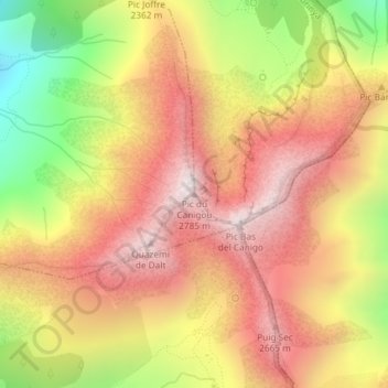
Name: Pic du Canigou topographic map, elevation, terrain.
Average elevation: 7,720 ft
Minimum elevation: 5,932 ft
Maximum elevation: 8,986 ft
Make a donation
Gear up for your next adventure:
As an Amazon Associate, this site earns from qualifying purchases at no extra cost to you.
Other topographic maps
Click on a map to view its topography, its elevation and its terrain.
La Llitéra
France > Occitanie > Pyrénées-Orientales > Taurinya
Née à 2 500 m d'altitude sur la costa de Sant Jaume (face Nord de la crête du Barbet), la rivière s'écoule vers le nord dans un large cirque pendant 2 km puis s'engouffre dans des gorges en se dirigeant vers le nord-nord-ouest. Alors qu'elle a dépassé la moitié de sa longueur, sa vallée s'élargit une…
Average elevation: 3,130 ft