Geolocate

Buchanan topographic map

Click on the map to display elevation.

About this map

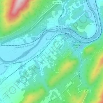
Name: Buchanan topographic map, elevation, terrain.

Location: Buchanan, Botetourt County, Virginia, 24066, United States (37.50360 -79.71564 37.54203 -79.66752)

Average elevation: 1,129 ft

Minimum elevation: 787 ft

Maximum elevation: 2,372 ft

Botetourt County trails, hiking, mountain biking, running and outdoor activities

Other topographic maps

Click on a map to view its topography, its elevation and its terrain.

Sandbank Mountain

United States > Virginia > Botetourt County

Average elevation: 2,654 ft

Eagle Rock

United States > Virginia > Botetourt County

Average elevation: 1,243 ft

Daleville

United States > Virginia > Botetourt County

Average elevation: 1,345 ft

Oriskany

United States > Virginia > Botetourt County

Average elevation: 1,325 ft

Glen Wilton

United States > Virginia > Botetourt County

Average elevation: 1,191 ft

Haden

United States > Virginia > Botetourt County > Haden

Average elevation: 1,112 ft

Gear up for your next adventure:

🛡️Bear Spray Outdoor - Protection in bear country hikes
📻Weather Alert Radios - Stay informed of storm risks while off-the-grid
🪑Ultralight Camp Chairs - Portable seating for resting after a long day of mapping
🌲Outdoor Survival Books - Best books on survival skills
🎒Hydration Pack - Hands‑free water reservoir for long hikes

As an Amazon Associate, this site earns from qualifying purchases at no extra cost to you.