Geolocate

Corozal topographic map

Click on the map to display elevation.

About this map

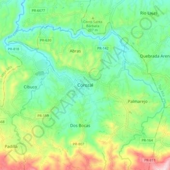
Name: Corozal topographic map, elevation, terrain.

Location: Corozal, Puerto Rico, 00687, United States (18.30059 -66.35724 18.38059 -66.27724)

Average elevation: 568 ft

Minimum elevation: 105 ft

Maximum elevation: 1,578 ft

Corozal trails, hiking, mountain biking, running and outdoor activities

Gear up for your next adventure:

🌲Outdoor Survival Books - Best books on survival skills
Backpacking Tent - Lightweight and durable tent for multi‑day hikes
🎒Outdoor Daypacks - Lightweight backpacks designed for carrying maps and essential gear
🦶Hiking Gaiters - Keep debris and water out of your boots
Solar GPS Watches - Advanced multisport watches with built-in topographic maps

As an Amazon Associate, this site earns from qualifying purchases at no extra cost to you.