
Kabwe topographic map
Interactive map
Click on the map to display elevation.
About this map
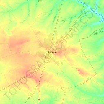
Name: Kabwe topographic map, elevation, terrain.
Location: Kabwe, Kabwe District, Central Province, Zambia (-14.48341 28.40652 -14.40341 28.48652)
Average elevation: 3,894 ft
Minimum elevation: 3,842 ft
Maximum elevation: 3,970 ft
Other topographic maps
Click on a map to view its topography, its elevation and its terrain.
Mabonde
Mabonde, Chitambo District, Central Province, Zambia
Average elevation: 4,957 ft