
Make a donation
Gear up for your next adventure:
As an Amazon Associate, this site earns from qualifying purchases at no extra cost to you.
Pic de Valsenestre topographic map
Click on the map to display elevation.
Make a donation
Gear up for your next adventure:
As an Amazon Associate, this site earns from qualifying purchases at no extra cost to you.
About this map
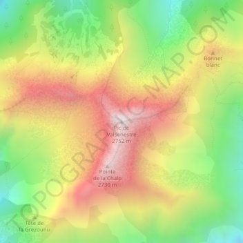
Name: Pic de Valsenestre topographic map, elevation, terrain.
Average elevation: 7,162 ft
Minimum elevation: 5,348 ft
Maximum elevation: 9,026 ft
Make a donation
Gear up for your next adventure:
As an Amazon Associate, this site earns from qualifying purchases at no extra cost to you.
Other topographic maps
Click on a map to view its topography, its elevation and its terrain.
Réserve naturelle de la haute vallée du Béranger
France > Auvergne-Rhône-Alpes > Isère > Valjouffrey > Valsenestre en Valjouffrey
Average elevation: 5,545 ft
Vallée du Béranger
France > Auvergne-Rhône-Alpes > Isère > Valjouffrey > Valsenestre en Valjouffrey
Valjouffrey s'étend sur la partie amont de la vallée de la Bonne, qui porte le nom de Valbonnais, ainsi que sur la totalité de la vallée du Béranger. L'altitude moyenne est de 2 244 m (cette moyenne tient compte des zones non habitées, l'altitude moyenne des hameaux étant quant à elle de 1 150 m). Les…
Average elevation: 6,716 ft