
Fort Mountain topographic map
Click on the map to display elevation.
About this map
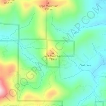
Name: Fort Mountain topographic map, elevation, terrain.
Location: Fort Mountain, Union County, Georgia, United States (34.81615 -83.94996 34.81625 -83.94986)
Average elevation: 2,228 ft
Minimum elevation: 1,900 ft
Maximum elevation: 2,959 ft
Union County trails, hiking, mountain biking, running and outdoor activities
Other topographic maps
Click on a map to view its topography, its elevation and its terrain.