
Make a donation
Gear up for your next adventure:
As an Amazon Associate, this site earns from qualifying purchases at no extra cost to you.
Alpe di Mera topographic map
Click on the map to display elevation.
Make a donation
Gear up for your next adventure:
As an Amazon Associate, this site earns from qualifying purchases at no extra cost to you.
Alpe di Mera
L'Alpe di Mera è una località valsesiana turistica montana situata nel comune di Scopello, in Piemonte, sulle Alpi Pennine, ad un'altitudine compresa tra i 1500 e i 1700 m sul livello del mare.
Make a donation
Gear up for your next adventure:
As an Amazon Associate, this site earns from qualifying purchases at no extra cost to you.
About this map
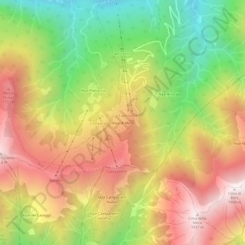
Name: Alpe di Mera topographic map, elevation, terrain.
Location: Alpe di Mera, Scopello, Vercelli, Piemonte, 13028, Italia (45.72567 8.06797 45.76567 8.10797)
Average elevation: 4,423 ft
Minimum elevation: 2,385 ft
Maximum elevation: 6,348 ft
Make a donation
Gear up for your next adventure:
As an Amazon Associate, this site earns from qualifying purchases at no extra cost to you.