Geolocate

Longridge topographic map

Click on the map to display elevation.

About this map

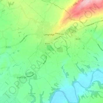
Name: Longridge topographic map, elevation, terrain.

Location: Longridge, Ribble Valley, Lancashire, England, United Kingdom (53.78932 -2.62472 53.85026 -2.54557)

Average elevation: 292 ft

Minimum elevation: 52 ft

Maximum elevation: 840 ft

Gear up for your next adventure:

🏕️Tent Footprint - Protect your tent base from wear
🪶Wildlife Field Guides - Learn animal tracking and species ID
🧭Hiking Compass - Precision compass for reliable navigation in the wilderness
📷Action Cameras - Rugged cameras to document your journeys across rugged terrain
🌡️Portable Weather Meter - Track weather conditions on the trail

As an Amazon Associate, this site earns from qualifying purchases at no extra cost to you.