
Thank you for supporting this site ❤️
Make a donation
Make a donation
Gear up for your next adventure:
As an Amazon Associate, this site earns from qualifying purchases at no extra cost to you.
Guerrouaou topographic map
Click on the map to display elevation.
Thank you for supporting this site ❤️
Make a donation
Make a donation
Gear up for your next adventure:
As an Amazon Associate, this site earns from qualifying purchases at no extra cost to you.
About this map
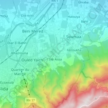
Name: Guerrouaou topographic map, elevation, terrain.
Location: Guerrouaou, Boufarik District, Blida, 09480, Algeria (36.45263 2.86710 36.55189 2.90285)
Average elevation: 1,207 ft
Minimum elevation: 223 ft
Maximum elevation: 4,888 ft
Thank you for supporting this site ❤️
Make a donation
Make a donation
Gear up for your next adventure:
As an Amazon Associate, this site earns from qualifying purchases at no extra cost to you.