
Make a donation
Gear up for your next adventure:
As an Amazon Associate, this site earns from qualifying purchases at no extra cost to you.
Newcastle topographic map
Click on the map to display elevation.
Make a donation
Gear up for your next adventure:
As an Amazon Associate, this site earns from qualifying purchases at no extra cost to you.
About this map
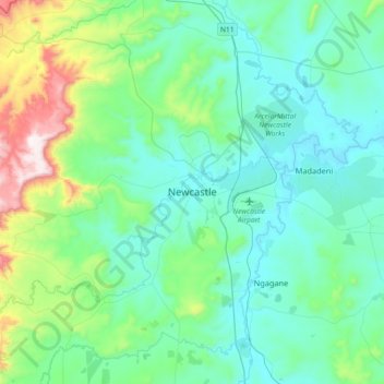
Name: Newcastle topographic map, elevation, terrain.
Average elevation: 4,311 ft
Minimum elevation: 3,832 ft
Maximum elevation: 6,581 ft
Make a donation
Gear up for your next adventure:
As an Amazon Associate, this site earns from qualifying purchases at no extra cost to you.
Other topographic maps
Click on a map to view its topography, its elevation and its terrain.
Dannhauser Local Municipality
South Africa > KwaZulu-Natal > Amajuba District Municipality
Average elevation: 4,262 ft
Newcastle Ward 17
South Africa > KwaZulu-Natal > Amajuba District Municipality > Newcastle Local Municipality > Osizweni
Average elevation: 4,032 ft
Zaaihoek Dam
South Africa > KwaZulu-Natal > Amajuba District Municipality > eMadlangeni Local Municipality
KwaZulu-Natal has a varied yet verdant climate thanks to diverse, complex topography. Generally, the coast is subtropical with inland regions becoming progressively colder. Durban on the south coast has an annual rainfall of 1009 mm, with daytime maxima peaking from January to March at 28 °C (82 °F) with a…
Average elevation: 5,682 ft
Make a donation
Gear up for your next adventure:
As an Amazon Associate, this site earns from qualifying purchases at no extra cost to you.
eMadlangeni Local Municipality
South Africa > KwaZulu-Natal > Amajuba District Municipality
Average elevation: 4,659 ft
Newcastle Local Municipality
South Africa > KwaZulu-Natal > Amajuba District Municipality
Average elevation: 5,039 ft
Dannhauser Local Municipality
South Africa > KwaZulu-Natal > Amajuba District Municipality
Average elevation: 4,262 ft
Make a donation
Gear up for your next adventure:
As an Amazon Associate, this site earns from qualifying purchases at no extra cost to you.