
Make a donation
Gear up for your next adventure:
As an Amazon Associate, this site earns from qualifying purchases at no extra cost to you.
Leusden topographic map
Click on the map to display elevation.
Make a donation
Gear up for your next adventure:
As an Amazon Associate, this site earns from qualifying purchases at no extra cost to you.
Leusden
In de zeventiende eeuw maakte de teelt van tabak een snelle groei door, dat in het gebied van de huidige gemeente Leusden rond 1700 haar hoogtepunt bereikte. Het was hier geschikt voor dankzij het gunstige klimaat, de bodem en goede verbindingen met belangrijke centra voor de handel en bewerking van tabak: Nijkerk, Amersfoort en Wageningen. In de achttiende eeuw werd, vanwege de gestegen prijzen, deels overgegaan op het verbouwen van graan. In de negentiende eeuw zou de teelt van tabak niet meer van belang zijn.
Make a donation
Gear up for your next adventure:
As an Amazon Associate, this site earns from qualifying purchases at no extra cost to you.
About this map
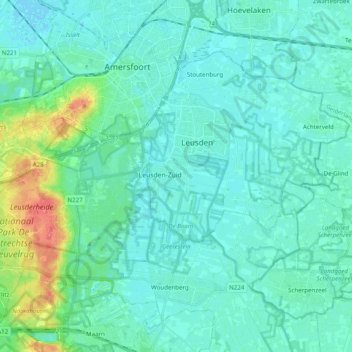
Name: Leusden topographic map, elevation, terrain.
Location: Leusden, Utrecht, Nederland (52.08933 5.31092 52.14821 5.50770)
Average elevation: 30 ft
Minimum elevation: -7 ft
Maximum elevation: 177 ft
Make a donation
Gear up for your next adventure:
As an Amazon Associate, this site earns from qualifying purchases at no extra cost to you.