
Make a donation
Gear up for your next adventure:
As an Amazon Associate, this site earns from qualifying purchases at no extra cost to you.
Fordland topographic map
Click on the map to display elevation.
Make a donation
Gear up for your next adventure:
As an Amazon Associate, this site earns from qualifying purchases at no extra cost to you.
Fordland
Due to its higher elevation compared to Springfield, a tower farm for the market's television and FM radio stations is located in Fordland.
Make a donation
Gear up for your next adventure:
As an Amazon Associate, this site earns from qualifying purchases at no extra cost to you.
About this map
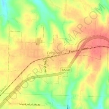
Name: Fordland topographic map, elevation, terrain.
Location: Fordland, Webster County, Missouri, United States (37.14986 -92.95531 37.16439 -92.92634)
Average elevation: 1,575 ft
Minimum elevation: 1,453 ft
Maximum elevation: 1,650 ft
Webster County trails, hiking, mountain biking, running and outdoor activities
Make a donation
Gear up for your next adventure:
As an Amazon Associate, this site earns from qualifying purchases at no extra cost to you.
Other topographic maps
Click on a map to view its topography, its elevation and its terrain.