
Make a donation
Gear up for your next adventure:
As an Amazon Associate, this site earns from qualifying purchases at no extra cost to you.
Zenar topographic map
Click on the map to display elevation.
Make a donation
Gear up for your next adventure:
As an Amazon Associate, this site earns from qualifying purchases at no extra cost to you.
About this map
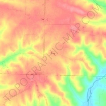
Name: Zenar topographic map, elevation, terrain.
Location: Zenar, Webster County, Missouri, 65642, United States (37.07505 -92.99045 37.11505 -92.95045)
Average elevation: 1,480 ft
Minimum elevation: 1,280 ft
Maximum elevation: 1,568 ft
Make a donation
Gear up for your next adventure:
As an Amazon Associate, this site earns from qualifying purchases at no extra cost to you.
Other topographic maps
Click on a map to view its topography, its elevation and its terrain.
Fordland
United States > Missouri > Webster County
Due to its higher elevation compared to Springfield, a tower farm for the market's television and FM radio stations is located in Fordland.
Average elevation: 1,575 ft
Make a donation
Gear up for your next adventure:
As an Amazon Associate, this site earns from qualifying purchases at no extra cost to you.
Fordland
United States > Missouri > Webster County
Due to favorable geographical conditions (e.g., altitude—Fordland is approximately 300 feet higher in elevation than Springfield), numerous Springfield-based media outlets, such as KYTV, KOLR, KOZL-TV, KGHZ, and others, have located their transmitting towers in or near Fordland.
Average elevation: 1,575 ft
Make a donation
Gear up for your next adventure:
As an Amazon Associate, this site earns from qualifying purchases at no extra cost to you.