
Mont-Joli topographic map
Interactive map
Click on the map to display elevation.
About this map
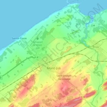
Name: Mont-Joli topographic map, elevation, terrain.
Location: Mont-Joli, La Mitis, Bas-Saint-Laurent, Quebec, Canada (48.54884 -68.25211 48.64440 -68.12504)
Average elevation: 207 ft
Minimum elevation: -13 ft
Maximum elevation: 702 ft
Other topographic maps
Click on a map to view its topography, its elevation and its terrain.
Mont Comi
Canada > Quebec > La Mitis > Saint-Donat
Mont Comi, Saint-Donat, La Mitis, Bas-Saint-Laurent, Quebec, Canada
Average elevation: 1,378 ft
Saint-Charles-Garnier
Saint-Charles-Garnier, La Mitis, Bas-Saint-Laurent, Quebec, Canada
Average elevation: 1,096 ft
Métis-sur-Mer
Métis-sur-Mer, La Mitis, Bas-Saint-Laurent, Quebec, G0J 1S0, Canada
Average elevation: 312 ft
Sainte-Jeanne-d'Arc
Sainte-Jeanne-d'Arc, La Mitis, Bas-Saint-Laurent, Quebec, Canada
Average elevation: 833 ft