Geolocate

Pinedale topographic map

Click on the map to display elevation.

Pinedale

Pinedale is located at 42°51′58″N 109°51′53″W / 42.86611°N 109.86472°W / 42.86611; -109.86472 (42.866162, −109.864622) and sits at an elevation of 7,175 feet above sea level. According to the United States Census Bureau, the town has a total area of 2.15 square miles (5.57 km2), all of it land.

About this map

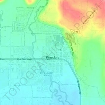
Name: Pinedale topographic map, elevation, terrain.

Location: Pinedale, Sublette County, Wyoming, United States of America (42.85574 -109.89101 42.88123 -109.85053)

Average elevation: 7,215 ft

Minimum elevation: 7,142 ft

Maximum elevation: 7,392 ft

Gear up for your next adventure:

🪑Portable Camp Table - Compact table for campsite meals
🧥Waterproof Jacket for Hiking - Breathable and rugged rain jacket for outdoor excursions
🔦Powerful Headlamps - Ultra-bright hands-free lighting for night navigation
🎒Hydration Pack - Hands‑free water reservoir for long hikes
Backpacking Tents - Weight-optimized shelters for multi-day topographic surveys

As an Amazon Associate, this site earns from qualifying purchases at no extra cost to you.