Geolocate

Mitternach topographic map

Click on the map to display elevation.

About this map

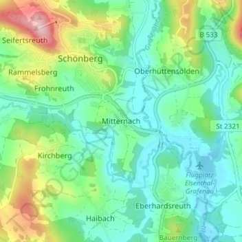
Name: Mitternach topographic map, elevation, terrain.

Location: Mitternach, Schönberg, Schönberg (VGem), Landkreis Freyung-Grafenau, Bayern, 94513, Deutschland (48.80933 13.32790 48.84933 13.36790)

Average elevation: 1,634 ft

Minimum elevation: 1,394 ft

Maximum elevation: 2,254 ft

Other topographic maps

Click on a map to view its topography, its elevation and its terrain.

94513

Deutschland > Bayern > Landkreis Freyung-Grafenau > Schönberg

Average elevation: 1,880 ft

Gear up for your next adventure:

🪶Multi‑Purpose Knife - Useful blade for camp and trail
🌄Hiking Binoculars - Compact binoculars for scenic views and trail spotting
⛑️Personal Locator Beacon - Safety beacon for emergencies
📡Handheld GPS Device - Reliable handheld GPS for outdoor navigation
🖼️Topo Map Wall Art - Decorative topographic prints of famous peaks and regions

As an Amazon Associate, this site earns from qualifying purchases at no extra cost to you.