Geolocate

Rhostyllen topographic map

Click on the map to display elevation.

About this map

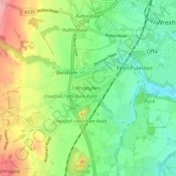
Name: Rhostyllen topographic map, elevation, terrain.

Location: Rhostyllen, Wrexham, Wales, LL14 4AD, United Kingdom (53.01163 -3.04519 53.05163 -3.00519)

Average elevation: 361 ft

Minimum elevation: 200 ft

Maximum elevation: 646 ft

Other topographic maps

Click on a map to view its topography, its elevation and its terrain.

Gwersyllt

United Kingdom > Wales > Wrexham

Average elevation: 367 ft

Penycae

United Kingdom > Wales > Wrexham

Average elevation: 1,148 ft

Rhosddu

United Kingdom > Wales > Wrexham

Average elevation: 289 ft

Bangor-on-Dee

United Kingdom > Wales > Wrexham

Average elevation: 98 ft

Cefn

United Kingdom > Wales > Wrexham > Acrefair

Average elevation: 466 ft

Gear up for your next adventure:

🧴Hand Sanitizer - Keep hands clean while hiking
📱Heavy-Duty Phone Cases - Drop-proof and waterproof protection for outdoor navigation
❄️Traction Cleats - Prevent slips on icy trails during winter hikes
🔪Outdoor Multitools - Essential survival tools for gear repair and field use
💧Water Purification System - Clean water on the trail with reliable purifiers

As an Amazon Associate, this site earns from qualifying purchases at no extra cost to you.