
Make a donation
Gear up for your next adventure:
As an Amazon Associate, this site earns from qualifying purchases at no extra cost to you.
Valle del Sol topographic map
Click on the map to display elevation.
Make a donation
Gear up for your next adventure:
As an Amazon Associate, this site earns from qualifying purchases at no extra cost to you.
About this map
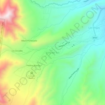
Name: Valle del Sol topographic map, elevation, terrain.
Average elevation: 6,788 ft
Minimum elevation: 5,955 ft
Maximum elevation: 8,350 ft
Make a donation
Gear up for your next adventure:
As an Amazon Associate, this site earns from qualifying purchases at no extra cost to you.
Other topographic maps
Click on a map to view its topography, its elevation and its terrain.
Puente del Inca
Argentina > Mendoza > Departamento Luján de Cuyo > Puente del Inca
Situated at 2,744 m (9,003 ft) above sea level, Puente del Inca has a warm-summer mediterranean continental climate (Dsb, according to the Köppen climate classification), as at least 4 months see an average temperature above 10 °C (50 °F) and at least one month sees an average temperature below 0 °C (32…
Average elevation: 9,862 ft
Distrito Ciudad de Luján de Cuyo
Argentina > Mendoza > Departamento Luján de Cuyo
Situated in the upper Mendoza valley, where the river is half-way through its journey from the Andes mountains to the eastern plains, many Lujan de Cuyo vineyards sit at altitudes of around 1000 m (3280 ft). Malbec in particular is successful in Lujan de Cuyo, but the appellation also produces good Cabernet…
Average elevation: 3,114 ft