
Make a donation
Gear up for your next adventure:
As an Amazon Associate, this site earns from qualifying purchases at no extra cost to you.
Table Rock topographic map
Click on the map to display elevation.
Make a donation
Gear up for your next adventure:
As an Amazon Associate, this site earns from qualifying purchases at no extra cost to you.
About this map
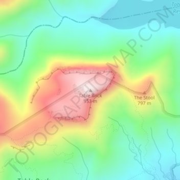
Name: Table Rock topographic map, elevation, terrain.
Location: Table Rock, Pickens County, South Carolina, United States (35.05062 -82.70351 35.05072 -82.70341)
Average elevation: 1,900 ft
Minimum elevation: 1,207 ft
Maximum elevation: 3,110 ft
Pickens County trails, hiking, mountain biking, running and outdoor activities
Make a donation
Gear up for your next adventure:
As an Amazon Associate, this site earns from qualifying purchases at no extra cost to you.
Other topographic maps
Click on a map to view its topography, its elevation and its terrain.
Jocassee Gorges Wildlife Management Area
United States > South Carolina > Pickens County
Average elevation: 1,726 ft
Make a donation
Gear up for your next adventure:
As an Amazon Associate, this site earns from qualifying purchases at no extra cost to you.