Geolocate

Ash topographic map

Click on the map to display elevation.

About this map

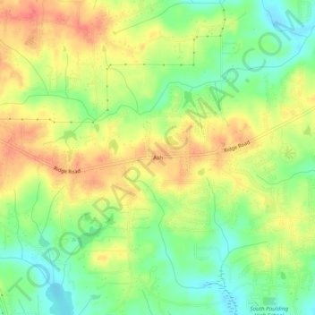
Name: Ash topographic map, elevation, terrain.

Location: Ash, Paulding County, Georgia, 30140, United States (33.78372 -84.87022 33.82372 -84.83022)

Average elevation: 1,047 ft

Minimum elevation: 951 ft

Maximum elevation: 1,138 ft

Paulding County trails, hiking, mountain biking, running and outdoor activities

Other topographic maps

Click on a map to view its topography, its elevation and its terrain.

Braswell

United States > Georgia > Paulding County

Average elevation: 1,079 ft

Gear up for your next adventure:

📦Dry Bags Set - Waterproof storage for electronics and clothes
🥾Men's Hiking Boots - Durable, waterproof footwear for rugged terrain and steep inclines
🏥Hiking First Aid Kits - Comprehensive medical kits for remote trail injuries
Camping Coffee Makers - Enjoy premium coffee at the summit or campsite
🏫Relief Map Kits - Hands-on tools for teaching landforms and elevation

As an Amazon Associate, this site earns from qualifying purchases at no extra cost to you.