Geolocate

Braswell topographic map

Click on the map to display elevation.

About this map

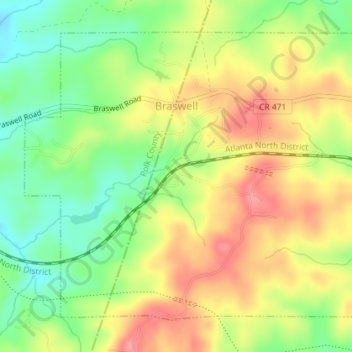
Name: Braswell topographic map, elevation, terrain.

Location: Braswell, Paulding County, Georgia, United States (33.97126 -84.97830 33.99567 -84.94235)

Average elevation: 1,079 ft

Minimum elevation: 932 ft

Maximum elevation: 1,224 ft

Paulding County trails, hiking, mountain biking, running and outdoor activities

Other topographic maps

Click on a map to view its topography, its elevation and its terrain.

New Hope

United States > Georgia > Paulding County

Average elevation: 1,040 ft

Hopecastle Forest

United States > Georgia > Paulding County

Average elevation: 1,040 ft

Nebo

United States > Georgia > Paulding County > Hiram

Average elevation: 1,040 ft

Cross Roads

United States > Georgia > Paulding County

Average elevation: 961 ft

Brownsville

United States > Georgia > Paulding County

Average elevation: 981 ft

Ray Mountain

United States > Georgia > Paulding County

Average elevation: 1,004 ft

Hickory Gap

United States > Georgia > Paulding County > Hickory Gap

Average elevation: 1,043 ft

Ash

United States > Georgia > Paulding County

Average elevation: 1,047 ft

Gear up for your next adventure:

🧭Outdoor Navigation Book - Learn advanced navigation skills
🛡️Insect Repellent - Protection against bugs during outdoor activities
🔥Fast-Boil Camping Stoves - Efficient cooking systems for quick trail meals
🥾Hiking Shoes - Durable and comfortable shoes for trail hiking
🎒Outdoor Daypacks - Lightweight backpacks designed for carrying maps and essential gear

As an Amazon Associate, this site earns from qualifying purchases at no extra cost to you.