
Make a donation
Gear up for your next adventure:
As an Amazon Associate, this site earns from qualifying purchases at no extra cost to you.
Laacher See topographic map
Click on the map to display elevation.
Make a donation
Gear up for your next adventure:
As an Amazon Associate, this site earns from qualifying purchases at no extra cost to you.
Laacher See
Das geförderte vulkanische Material war vorwiegend von phonolithischem Typ, der nur in der dritten Phase einen zunehmend höheren Anteil an primitiverem mafischem Material enthielt. Über die Gesamtmenge des Materials herrscht Uneinigkeit. So ist von 6 km³ DRE entsprechend 16–20 km³ Lockermassen die Rede, aber es wird auch eine Diskrepanz mit der zugehörigen Magmakammer diskutiert, die nur eine deutlich geringere (10 %) Menge an gefördertem Material zulässt. Ebenfalls ist unklar, ob es ein, zwei oder noch mehr Ausbruchszentren existieren. beziehend auf Weitere allgemeine Informationen z. B.
Make a donation
Gear up for your next adventure:
As an Amazon Associate, this site earns from qualifying purchases at no extra cost to you.
About this map
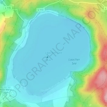
Name: Laacher See topographic map, elevation, terrain.
Average elevation: 1,030 ft
Minimum elevation: 889 ft
Maximum elevation: 1,490 ft
Make a donation
Gear up for your next adventure:
As an Amazon Associate, this site earns from qualifying purchases at no extra cost to you.
Other topographic maps
Click on a map to view its topography, its elevation and its terrain.
Abtei Maria Laach
Deutschland > Rheinland-Pfalz > Landkreis Ahrweiler > Glees > Abtei Maria Laach
Average elevation: 1,083 ft