
Make a donation
Gear up for your next adventure:
As an Amazon Associate, this site earns from qualifying purchases at no extra cost to you.
Severna Park topographic map
Click on the map to display elevation.
Make a donation
Gear up for your next adventure:
As an Amazon Associate, this site earns from qualifying purchases at no extra cost to you.
About this map
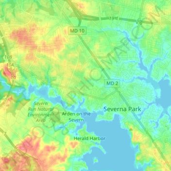
Name: Severna Park topographic map, elevation, terrain.
Location: Severna Park, Anne Arundel County, Maryland, United States (39.04052 -76.63290 39.12611 -76.50832)
Average elevation: 66 ft
Minimum elevation: -10 ft
Maximum elevation: 200 ft
Anne Arundel County trails, hiking, mountain biking, running and outdoor activities
Make a donation
Gear up for your next adventure:
As an Amazon Associate, this site earns from qualifying purchases at no extra cost to you.
Other topographic maps
Click on a map to view its topography, its elevation and its terrain.
Longmeadow North
United States > Maryland > Anne Arundel County > Severna Park
Average elevation: 26 ft
Lower Magothy Beach
United States > Maryland > Anne Arundel County > Severna Park > Lower Magothy Beach
Average elevation: 30 ft
Windrush Farm
United States > Maryland > Anne Arundel County > Severna Park > Windrush Farm
Average elevation: 33 ft
Make a donation
Gear up for your next adventure:
As an Amazon Associate, this site earns from qualifying purchases at no extra cost to you.
Severndale
United States > Maryland > Anne Arundel County > Severna Park > Severndale
Average elevation: 59 ft
Linstead-on-the-Severn
United States > Maryland > Anne Arundel County > Severna Park
Average elevation: 36 ft