
De Fryske Marren topographic map
Interactive map
Click on the map to display elevation.
About this map
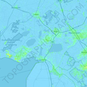
Name: De Fryske Marren topographic map, elevation, terrain.
Location: De Fryske Marren, Friesland, Niederlande (52.76481 5.33784 53.05884 5.93785)
Average elevation: 0 ft
Minimum elevation: -23 ft
Maximum elevation: 39 ft
Other topographic maps
Click on a map to view its topography, its elevation and its terrain.
Rohel
Niederlande > Friesland > De Fryske Marren
Rohel, De Fryske Marren, Friesland, Niederlande
Average elevation: -3 ft
Elahuizen
Niederlande > Friesland > De Fryske Marren
Elahuizen, De Fryske Marren, Friesland, Niederlande
Average elevation: -7 ft