Geolocate

Vellmar topographic map

Click on the map to display elevation.

About this map

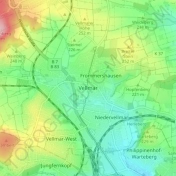
Name: Vellmar topographic map, elevation, terrain.

Location: Vellmar, Landkreis Kassel, Hesse, 34246, Germany (51.34246 9.42818 51.38203 9.50092)

Average elevation: 712 ft

Minimum elevation: 509 ft

Maximum elevation: 1,102 ft

Other topographic maps

Click on a map to view its topography, its elevation and its terrain.

Hirschköpfchen

Germany > Hesse > Landkreis Kassel

Average elevation: 968 ft

Trendelburg

Germany > Hesse > Landkreis Kassel

Average elevation: 653 ft

Gear up for your next adventure:

🚑Emergency Bivvies - Heat-reflective sleeping bags for survival situations
🧭Compass with Lanyard - Easy‑carry compass for navigation
Camping Coffee Makers - Enjoy premium coffee at the summit or campsite
🎒Hydration Pack - Hands‑free water reservoir for long hikes
Solar GPS Watches - Advanced multisport watches with built-in topographic maps

As an Amazon Associate, this site earns from qualifying purchases at no extra cost to you.