
Make a donation
Gear up for your next adventure:
As an Amazon Associate, this site earns from qualifying purchases at no extra cost to you.
Herne Bay topographic map
Click on the map to display elevation.
Make a donation
Gear up for your next adventure:
As an Amazon Associate, this site earns from qualifying purchases at no extra cost to you.
About this map
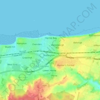
Name: Herne Bay topographic map, elevation, terrain.
Location: Herne Bay, Kent, England, United Kingdom (51.35366 1.08662 51.37642 1.17813)
Average elevation: 56 ft
Minimum elevation: 0 ft
Maximum elevation: 194 ft
Make a donation
Gear up for your next adventure:
As an Amazon Associate, this site earns from qualifying purchases at no extra cost to you.
Other topographic maps
Click on a map to view its topography, its elevation and its terrain.
Nelson Park
United Kingdom > England > Kent > Dover > St. Margaret's at Cliffe
Average elevation: 226 ft
Make a donation
Gear up for your next adventure:
As an Amazon Associate, this site earns from qualifying purchases at no extra cost to you.
White Cliffs of Dover
United Kingdom > England > Kent > Dover > St. Margaret's at Cliffe
Average elevation: 161 ft
Make a donation
Gear up for your next adventure:
As an Amazon Associate, this site earns from qualifying purchases at no extra cost to you.
Make a donation
Gear up for your next adventure:
As an Amazon Associate, this site earns from qualifying purchases at no extra cost to you.
Make a donation
Gear up for your next adventure:
As an Amazon Associate, this site earns from qualifying purchases at no extra cost to you.
Make a donation
Gear up for your next adventure:
As an Amazon Associate, this site earns from qualifying purchases at no extra cost to you.
Park Gate
United Kingdom > England > Kent > Folkestone and Hythe District > Elham
Average elevation: 427 ft