Geolocate

Timago topographic map

Click on the map to display elevation.

About this map

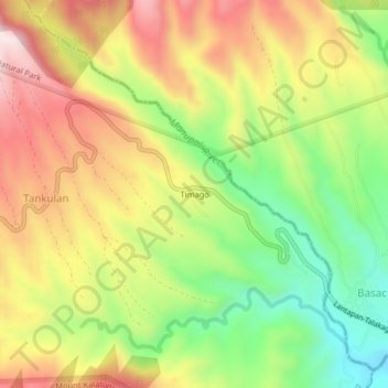
Name: Timago topographic map, elevation, terrain.

Location: Timago, Talakag, Bukidnon, Northern Mindanao, Philippines (8.03245 124.82608 8.07245 124.86608)

Average elevation: 4,281 ft

Minimum elevation: 3,465 ft

Maximum elevation: 5,121 ft

Other topographic maps

Click on a map to view its topography, its elevation and its terrain.

Cagayan de Oro River

Philippines > Bukidnon > Talakag > San Isidro

Average elevation: 1,030 ft

Gear up for your next adventure:

🗻Climbing Gear Basics - Essential gear for beginner climbers
🧤Hiking Gloves - Protective gloves for rugged trails
📱Heavy-Duty Phone Cases - Drop-proof and waterproof protection for outdoor navigation
🧺Microfiber Travel Towels - Compact and fast-drying towels for trail use
🪶Thermal Camp Blanket - Extra warmth for cold nights

As an Amazon Associate, this site earns from qualifying purchases at no extra cost to you.