
Make a donation
Gear up for your next adventure:
As an Amazon Associate, this site earns from qualifying purchases at no extra cost to you.
Webbekom topographic map
Click on the map to display elevation.
Make a donation
Gear up for your next adventure:
As an Amazon Associate, this site earns from qualifying purchases at no extra cost to you.
Webbekom
Webbekom ligt in het Hageland en de hoogte bedraagt 20-76 meter. Getuigenheuvels zijn Parelsberg (41 meter), Kloosterberg (53 meter) en Blakenberg (77 meter). Nabij Webbekom stroomt het Zwart Water.
Make a donation
Gear up for your next adventure:
As an Amazon Associate, this site earns from qualifying purchases at no extra cost to you.
About this map
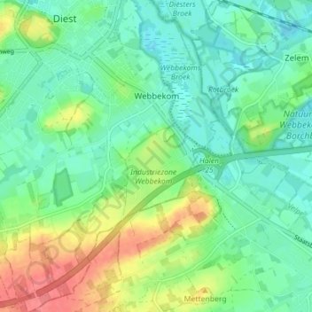
Name: Webbekom topographic map, elevation, terrain.
Location: Webbekom, Diest, Leuven, Vlaams-Brabant, Vlaanderen, België (50.94277 5.02638 50.98697 5.08516)
Average elevation: 108 ft
Minimum elevation: 43 ft
Maximum elevation: 246 ft
Make a donation
Gear up for your next adventure:
As an Amazon Associate, this site earns from qualifying purchases at no extra cost to you.
Other topographic maps
Click on a map to view its topography, its elevation and its terrain.
Make a donation
Gear up for your next adventure:
As an Amazon Associate, this site earns from qualifying purchases at no extra cost to you.