Geolocate

Middlesboro topographic map

Click on the map to display elevation.

About this map
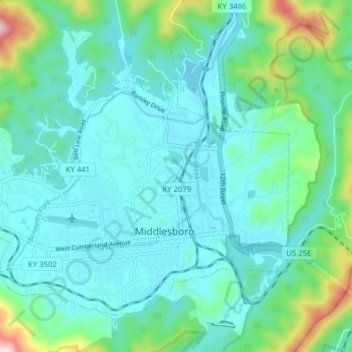
Name: Middlesboro topographic map, elevation, terrain.

Location: Middlesboro, Bell County, Kentucky, United States (36.59332 -83.76681 36.64296 -83.68887)

Average elevation: 1,332 ft

Minimum elevation: 1,099 ft

Maximum elevation: 2,490 ft

Bell County trails, hiking, mountain biking, running and outdoor activities

Other topographic maps

Click on a map to view its topography, its elevation and its terrain.

Frakes

United States > Kentucky > Bell County

Average elevation: 1,667 ft

Fonde

United States > Kentucky > Bell County

Average elevation: 1,880 ft

Pineville

United States > Kentucky > Bell County > Pineville > Pineville

Average elevation: 1,486 ft

Tejay

United States > Kentucky > Bell County

Average elevation: 1,391 ft

Black Snake

United States > Kentucky > Bell County

Average elevation: 1,667 ft

Gear up for your next adventure:

🏕️Tent Footprint - Protect your tent base from wear
⛺Backpacking Tents - Weight-optimized shelters for multi-day topographic surveys
📦Dry Bags Set - Waterproof storage for electronics and clothes
🔌Solar Panel Charger - Charge gear sustainably outdoors
🧭Compass with Lanyard - Easy‑carry compass for navigation

As an Amazon Associate, this site earns from qualifying purchases at no extra cost to you.