Geolocate

Cerano topographic map

Click on the map to display elevation.

About this map

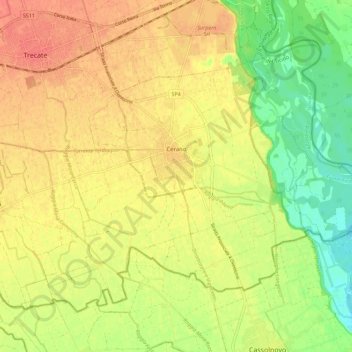
Name: Cerano topographic map, elevation, terrain.

Location: Cerano, Novara, Piemonte, 28065, Italia (45.37438 8.73045 45.43537 8.84290)

Average elevation: 400 ft

Minimum elevation: 305 ft

Maximum elevation: 469 ft

Other topographic maps

Click on a map to view its topography, its elevation and its terrain.

Sovazza

Italia > Piemonte > Novara

Average elevation: 2,238 ft

Gaggiolo

Italia > Piemonte > Novara

Average elevation: 692 ft

Gattico

Italia > Piemonte > Novara

Average elevation: 1,109 ft

Fosseno

Italia > Piemonte > Novara

Average elevation: 1,798 ft

Coiromonte

Italia > Piemonte > Novara

Average elevation: 2,425 ft

Tabarino

Italia > Piemonte > Novara

Average elevation: 1,821 ft

Gear up for your next adventure:

🩹Survival Bandages - High‑quality bandages for emergencies
🥘Titanium Cookware - Durable, featherlight pots and pans for backpacking
🦶Hiking Gaiters - Keep debris and water out of your boots
🏔️Mountain Trail Maps - High‑detail maps for popular peaks
🪶Multi‑Purpose Knife - Useful blade for camp and trail

As an Amazon Associate, this site earns from qualifying purchases at no extra cost to you.