
Make a donation
Gear up for your next adventure:
As an Amazon Associate, this site earns from qualifying purchases at no extra cost to you.
McDonald topographic map
Click on the map to display elevation.
Make a donation
Gear up for your next adventure:
As an Amazon Associate, this site earns from qualifying purchases at no extra cost to you.
About this map
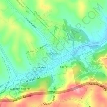
Name: McDonald topographic map, elevation, terrain.
Location: McDonald, Washington County, Pennsylvania, United States (40.36423 -80.24343 40.37748 -80.22051)
Average elevation: 1,109 ft
Minimum elevation: 955 ft
Maximum elevation: 1,368 ft
Washington County trails, hiking, mountain biking, running and outdoor activities
Make a donation
Gear up for your next adventure:
As an Amazon Associate, this site earns from qualifying purchases at no extra cost to you.
Other topographic maps
Click on a map to view its topography, its elevation and its terrain.
McMillan
United States > Pennsylvania > Washington County > Donegal Township
Average elevation: 1,171 ft
Make a donation
Gear up for your next adventure:
As an Amazon Associate, this site earns from qualifying purchases at no extra cost to you.
Stogletown
United States > Pennsylvania > Washington County > Monongahela > Monongahela
Average elevation: 955 ft
Hill Church
United States > Pennsylvania > Washington County > North Strabane Township
Average elevation: 1,135 ft
Enterprise
United States > Pennsylvania > Washington County > South Strabane Township
Average elevation: 1,096 ft
Hazel Kirk
United States > Pennsylvania > Washington County > Carroll Township
Average elevation: 1,020 ft
Make a donation
Gear up for your next adventure:
As an Amazon Associate, this site earns from qualifying purchases at no extra cost to you.
Richeyville
United States > Pennsylvania > Washington County > Centerville
Average elevation: 1,138 ft
Vestaburg
United States > Pennsylvania > Washington County > East Bethlehem Township
Average elevation: 1,010 ft
Prosperity
United States > Pennsylvania > Washington County > Morris Township > Prosperity
Average elevation: 1,155 ft
Make a donation
Gear up for your next adventure:
As an Amazon Associate, this site earns from qualifying purchases at no extra cost to you.
Venetia
United States > Pennsylvania > Washington County > Peters Township
Average elevation: 1,122 ft
Bulger
United States > Pennsylvania > Washington County > Smith Township > Bulger
Average elevation: 1,161 ft
Eighty Four
United States > Pennsylvania > Washington County > North Strabane Township
Average elevation: 1,132 ft
Make a donation
Gear up for your next adventure:
As an Amazon Associate, this site earns from qualifying purchases at no extra cost to you.
Acheson
United States > Pennsylvania > Washington County > Independence Township
Average elevation: 1,066 ft
Bower Hill
United States > Pennsylvania > Washington County > Peters Township
Average elevation: 1,142 ft
Ten Mile
United States > Pennsylvania > Washington County > Amwell Township
Average elevation: 1,093 ft
Strabane
United States > Pennsylvania > Washington County > North Strabane Township
Average elevation: 1,079 ft
Make a donation
Gear up for your next adventure:
As an Amazon Associate, this site earns from qualifying purchases at no extra cost to you.
Lake Jo-Ann
United States > Pennsylvania > Washington County > Peters Township
Average elevation: 1,125 ft
Hickory
United States > Pennsylvania > Washington County > Mount Pleasant Township
Average elevation: 1,217 ft
Fredericktown
United States > Pennsylvania > Washington County > East Bethlehem Township
Average elevation: 1,004 ft
Make a donation
Gear up for your next adventure:
As an Amazon Associate, this site earns from qualifying purchases at no extra cost to you.
Buffalo
United States > Pennsylvania > Washington County > Hopewell Township > Buffalo
Average elevation: 1,214 ft
Murry Hill
United States > Pennsylvania > Washington County > North Strabane Township
Average elevation: 1,047 ft
Clover Hill
United States > Pennsylvania > Washington County > West Pike Run Township > Clover Hill
Average elevation: 1,138 ft