
Thank you for supporting this site ❤️
Make a donation
Make a donation
Gear up for your next adventure:
As an Amazon Associate, this site earns from qualifying purchases at no extra cost to you.
Weißag topographic map
Click on the map to display elevation.
Thank you for supporting this site ❤️
Make a donation
Make a donation
Gear up for your next adventure:
As an Amazon Associate, this site earns from qualifying purchases at no extra cost to you.
Weißag
Weißag liegt am südlichen Rand der Calauer Schweiz. Nördlich des Ortes liegen die sogenannten Weißager Berge, deren höchste „Erhebung“ der Spitzberg mit einer Höhe von 144 m ü. NHN ist.
Thank you for supporting this site ❤️
Make a donation
Make a donation
Gear up for your next adventure:
As an Amazon Associate, this site earns from qualifying purchases at no extra cost to you.
About this map
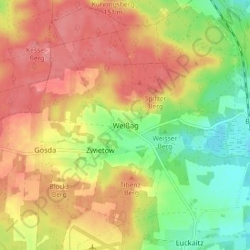
Name: Weißag topographic map, elevation, terrain.
Average elevation: 417 ft
Minimum elevation: 282 ft
Maximum elevation: 522 ft
Thank you for supporting this site ❤️
Make a donation
Make a donation
Gear up for your next adventure:
As an Amazon Associate, this site earns from qualifying purchases at no extra cost to you.