
Thank you for supporting this site ❤️
Make a donation
Make a donation
Gear up for your next adventure:
As an Amazon Associate, this site earns from qualifying purchases at no extra cost to you.
Telnice topographic map
Click on the map to display elevation.
Thank you for supporting this site ❤️
Make a donation
Make a donation
Gear up for your next adventure:
As an Amazon Associate, this site earns from qualifying purchases at no extra cost to you.
About this map
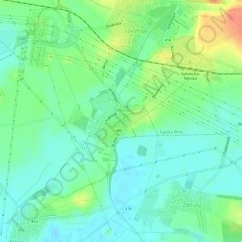
Name: Telnice topographic map, elevation, terrain.
Location: Telnice, okres Brno-venkov, Jihomoravský kraj, 664 59, Czechia (49.08751 16.68184 49.11307 16.73652)
Average elevation: 650 ft
Minimum elevation: 600 ft
Maximum elevation: 751 ft
Thank you for supporting this site ❤️
Make a donation
Make a donation
Gear up for your next adventure:
As an Amazon Associate, this site earns from qualifying purchases at no extra cost to you.