Geolocate

Taggart topographic map

Click on the map to display elevation.

About this map

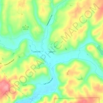
Name: Taggart topographic map, elevation, terrain.

Location: Taggart, Brown County, Indiana, United States (39.24172 -86.15888 39.28172 -86.11888)

Average elevation: 778 ft

Minimum elevation: 627 ft

Maximum elevation: 978 ft

Brown County trails, hiking, mountain biking, running and outdoor activities

Gear up for your next adventure:

🧤Hiking Gloves - Protective gloves for rugged trails
🌲Outdoor Survival Books - Best books on survival skills
🧷Carabiner Set - Durable clips for gear attachment
📡GPS Antenna Upgrade - Enhance GPS reception in remote terrain
🧭Compass with Lanyard - Easy‑carry compass for navigation

As an Amazon Associate, this site earns from qualifying purchases at no extra cost to you.