Geolocate

Lamkin topographic map

Interactive map

Click on the map to display elevation.

About this map

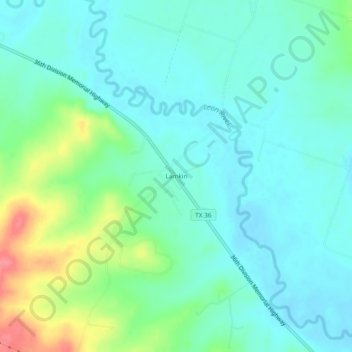
Name: Lamkin topographic map, elevation, terrain.

Location: Lamkin, Comanche County, Texas, United States (31.80321 -98.28421 31.84321 -98.24421)

Average elevation: 1,102 ft

Minimum elevation: 1,037 ft

Maximum elevation: 1,289 ft

Other topographic maps

Click on a map to view its topography, its elevation and its terrain.

Comanche

United States > Texas > Comanche County

Comanche, Comanche County, Texas, 76442, United States

Average elevation: 1,394 ft

Energy

United States > Texas > Comanche County

Energy, Comanche County, Texas, 76452, United States

Average elevation: 1,391 ft

Gustine

United States > Texas > Comanche County

Gustine, Comanche County, Texas, 76455, United States

Average elevation: 1,158 ft

De Leon

United States > Texas > Comanche County

De Leon, Comanche County, Texas, United States

Average elevation: 1,309 ft

Sidney

United States > Texas > Comanche County

Sidney, Comanche County, Texas, 76474, United States

Average elevation: 1,450 ft