
Make a donation
Gear up for your next adventure:
As an Amazon Associate, this site earns from qualifying purchases at no extra cost to you.
Townville topographic map
Click on the map to display elevation.
Make a donation
Gear up for your next adventure:
As an Amazon Associate, this site earns from qualifying purchases at no extra cost to you.
Townville
The borough is in a valley at the height of land between north-flowing Muddy Creek and south-flowing Sugar Creek, both tributaries of French Creek and part of the Allegheny River watershed. The lowest elevation in Townville is 1,370 ft (420 m) on the southern boundary at the wetland that is drained by Muddy Creek and Sugar Creek. The highest elevation is 1,500 ft (460 m) on the western boundary.
Make a donation
Gear up for your next adventure:
As an Amazon Associate, this site earns from qualifying purchases at no extra cost to you.
About this map
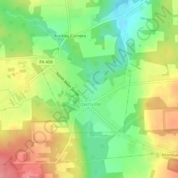
Name: Townville topographic map, elevation, terrain.
Average elevation: 1,476 ft
Minimum elevation: 1,332 ft
Maximum elevation: 1,644 ft
Crawford County trails, hiking, mountain biking, running and outdoor activities
Make a donation
Gear up for your next adventure:
As an Amazon Associate, this site earns from qualifying purchases at no extra cost to you.
Other topographic maps
Click on a map to view its topography, its elevation and its terrain.
Teepleville
United States > Pennsylvania > Crawford County > Richmond Township
Average elevation: 1,266 ft
Franklin Pike Corners
United States > Pennsylvania > Crawford County > West Mead Township
Average elevation: 1,237 ft
Make a donation
Gear up for your next adventure:
As an Amazon Associate, this site earns from qualifying purchases at no extra cost to you.