
Make a donation
Gear up for your next adventure:
As an Amazon Associate, this site earns from qualifying purchases at no extra cost to you.
Solon Springs topographic map
Click on the map to display elevation.
Make a donation
Gear up for your next adventure:
As an Amazon Associate, this site earns from qualifying purchases at no extra cost to you.
About this map
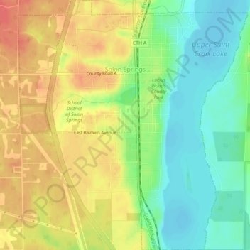
Name: Solon Springs topographic map, elevation, terrain.
Location: Solon Springs, Douglas County, Wisconsin, United States (46.33122 -91.84130 46.36162 -91.80080)
Average elevation: 1,096 ft
Minimum elevation: 1,007 ft
Maximum elevation: 1,184 ft
Douglas County trails, hiking, mountain biking, running and outdoor activities
Make a donation
Gear up for your next adventure:
As an Amazon Associate, this site earns from qualifying purchases at no extra cost to you.
Other topographic maps
Click on a map to view its topography, its elevation and its terrain.
Big Manitou Falls
United States > Wisconsin > Douglas County > Town of Superior
Average elevation: 968 ft
Make a donation
Gear up for your next adventure:
As an Amazon Associate, this site earns from qualifying purchases at no extra cost to you.