
Whitewood topographic map
Click on the map to display elevation.
About this map
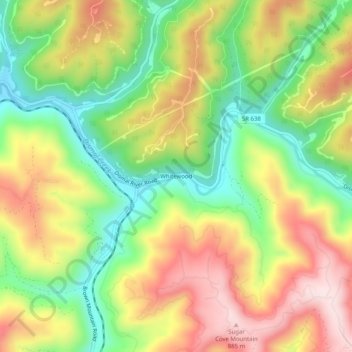
Name: Whitewood topographic map, elevation, terrain.
Location: Whitewood, Buchanan County, Virginia, 24657, United States (37.21567 -81.87706 37.25567 -81.83706)
Average elevation: 2,211 ft
Minimum elevation: 1,621 ft
Maximum elevation: 2,871 ft
Buchanan County trails, hiking, mountain biking, running and outdoor activities
Other topographic maps
Click on a map to view its topography, its elevation and its terrain.
Breaks Interstate Park
United States > Virginia > Buchanan County > Conaway
Average elevation: 1,565 ft