Geolocate

Llangwm topographic map

Click on the map to display elevation.

About this map

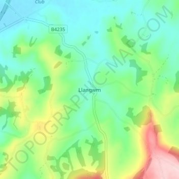
Name: Llangwm topographic map, elevation, terrain.

Location: Llangwm, Monmouthshire, Wales, NP15 1HG, United Kingdom (51.67569 -2.85201 51.71569 -2.81201)

Average elevation: 299 ft

Minimum elevation: 62 ft

Maximum elevation: 850 ft

Other topographic maps

Click on a map to view its topography, its elevation and its terrain.

Wye Valley

United Kingdom > Wales > Monmouthshire

Average elevation: 548 ft

Chepstow Castle

United Kingdom > Wales > Monmouthshire > Chepstow

Average elevation: 174 ft

Penallt

United Kingdom > Wales > Monmouthshire

Average elevation: 571 ft

Crucorney

United Kingdom > Wales > Monmouthshire

Average elevation: 974 ft

Blorenge

United Kingdom > Wales > Monmouthshire > Govilon

Average elevation: 1,293 ft

River Monnow

United Kingdom > Wales > Monmouthshire

Average elevation: 564 ft

Llanbadoc

United Kingdom > Wales > Monmouthshire

Average elevation: 256 ft

Raglan Castle

United Kingdom > Wales > Monmouthshire > Raglan

Average elevation: 194 ft

River Monnow

United Kingdom > Wales > Monmouthshire

Average elevation: 564 ft

Gear up for your next adventure:

🪵Folding Camp Saw - Compact saw for wood and campsite work
🌧️Backpack Rain Cover - Keep gear dry in wet weather
🧣Hiking Neck Gaiter - Multi‑use neck protection for outdoor weather
🗻Climbing Gear Basics - Essential gear for beginner climbers
🪶Multi‑Purpose Knife - Useful blade for camp and trail

As an Amazon Associate, this site earns from qualifying purchases at no extra cost to you.