Geolocate

Iron Gate topographic map

Click on the map to display elevation.

About this map

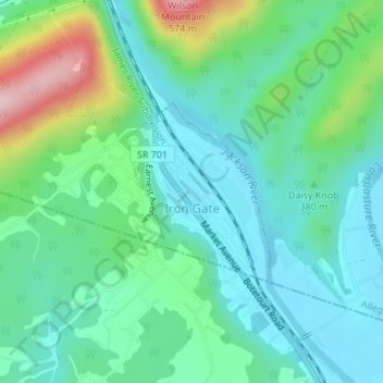
Name: Iron Gate topographic map, elevation, terrain.

Location: Iron Gate, Alleghany County, Virginia, 24448, United States (37.79242 -79.79690 37.80506 -79.78419)

Average elevation: 1,217 ft

Minimum elevation: 988 ft

Maximum elevation: 1,883 ft

Alleghany County trails, hiking, mountain biking, running and outdoor activities

Other topographic maps

Click on a map to view its topography, its elevation and its terrain.

Callaghan

United States > Virginia > Alleghany County

Average elevation: 1,608 ft

Cliftondale Park

United States > Virginia > Alleghany County

Average elevation: 1,293 ft

Lewis Mountain

United States > Virginia > Alleghany County

Average elevation: 2,434 ft

Backbone

United States > Virginia > Alleghany County

Average elevation: 1,873 ft

Gear up for your next adventure:

❄️Traction Cleats - Prevent slips on icy trails during winter hikes
📌Outdoor GPS Map App - Apps and devices for digital topographic navigation
🛌Ultralight Sleeping Bags - Compact down bags for cold nights in the wilderness
👓Polarized Sunglasses - Outdoor sunglasses for glare reduction
🚁Photography Drones - Capture stunning aerial views of landforms and topography

As an Amazon Associate, this site earns from qualifying purchases at no extra cost to you.