
Potrero Grande topographic map
Interactive map
Click on the map to display elevation.
About this map
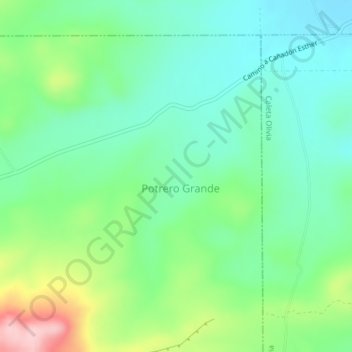
Name: Potrero Grande topographic map, elevation, terrain.
Location: Potrero Grande, Deseado, Santa Cruz, Argentina (-46.45971 -67.66019 -46.43806 -67.64093)
Average elevation: 597 ft
Minimum elevation: 407 ft
Maximum elevation: 1,040 ft
Other topographic maps
Click on a map to view its topography, its elevation and its terrain.
Cerro Buenos Aires
Cerro Buenos Aires, Lago Argentino, Santa Cruz, Argentina
Average elevation: 4,104 ft
La Estrella
La Estrella, Deseado, Santa Cruz, Argentina
Average elevation: 246 ft
Laguna del Carbón
Laguna del Carbón, Corpen Aike, Santa Cruz, Argentina
Average elevation: -335 ft