Geolocate

Suleja topographic map

Click on the map to display elevation.

About this map

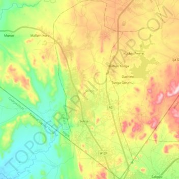
Name: Suleja topographic map, elevation, terrain.

Location: Suleja, Niger State, Nigeria (9.11351 7.14794 9.30430 7.23397)

Average elevation: 1,385 ft

Minimum elevation: 650 ft

Maximum elevation: 2,421 ft

Other topographic maps

Click on a map to view its topography, its elevation and its terrain.

New Dugga

Nigeria > Niger State > Borgu

Average elevation: 495 ft

Tudun Fulani

Nigeria > Niger State > Bosso

Average elevation: 1,112 ft

Kainji Dam

Nigeria > Niger State > Magama > Faku

Average elevation: 423 ft

Paiko

Nigeria > Niger State > Paikoro

Average elevation: 1,001 ft

Minna

Nigeria > Niger State > Chanchaga

Average elevation: 892 ft

Gear up for your next adventure:

🛠️Outdoor Gear Repair Kit - Essential tools to fix gear on the trail
🔦Compact Flashlight - Reliable flashlight for emergencies
📖Nature Tracking Books - Learn to track wildlife and terrain
🛠️Backpacking Tool Kit - Essential toolkit for outdoor repairs
🗻Climbing Gear Basics - Essential gear for beginner climbers

As an Amazon Associate, this site earns from qualifying purchases at no extra cost to you.