
Thank you for supporting this site ❤️
Make a donation
Make a donation
Gear up for your next adventure:
As an Amazon Associate, this site earns from qualifying purchases at no extra cost to you.
Canegreca topographic map
Click on the map to display elevation.
Thank you for supporting this site ❤️
Make a donation
Make a donation
Gear up for your next adventure:
As an Amazon Associate, this site earns from qualifying purchases at no extra cost to you.
About this map
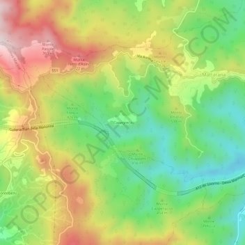
Name: Canegreca topographic map, elevation, terrain.
Location: Canegreca, Carrodano, La Spezia, Liguria, 19012, Italy (44.21926 9.58275 44.25926 9.62275)
Average elevation: 1,509 ft
Minimum elevation: 659 ft
Maximum elevation: 2,585 ft
Thank you for supporting this site ❤️
Make a donation
Make a donation
Gear up for your next adventure:
As an Amazon Associate, this site earns from qualifying purchases at no extra cost to you.