
Make a donation
Gear up for your next adventure:
As an Amazon Associate, this site earns from qualifying purchases at no extra cost to you.
Taihang Mountains topographic map
Click on the map to display elevation.
Make a donation
Gear up for your next adventure:
As an Amazon Associate, this site earns from qualifying purchases at no extra cost to you.
About this map
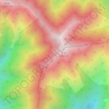
Name: Taihang Mountains topographic map, elevation, terrain.
Location: Taihang Mountains, Zhangjiakou, Hebei, China (39.93995 115.03995 39.94005 115.04005)
Average elevation: 7,992 ft
Minimum elevation: 6,142 ft
Maximum elevation: 9,350 ft
Make a donation
Gear up for your next adventure:
As an Amazon Associate, this site earns from qualifying purchases at no extra cost to you.
Other topographic maps
Click on a map to view its topography, its elevation and its terrain.
Zhangjiakou
China > Hebei > Zhangjiakou
Um Tourismus aus anderen Regionen Chinas anzulocken strebt die Stadtregierung das Ziel an, Zhangjiakou zu einem nationalen Wintersportzentrum zu machen und wirbt um Investitionen in Höhe von 1 Milliarde US-Dollar für die Entwicklung des Saibei Skiing Resorts 塞北滑雪场 und des Hebei Cuiyunshan…
Average elevation: 3,947 ft