Geolocate

Smithville topographic map

Click on the map to display elevation.

About this map

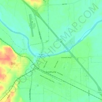
Name: Smithville topographic map, elevation, terrain.

Location: Smithville, Bastrop County, Texas, 78957, United States (29.99144 -97.17709 30.04010 -97.11988)

Average elevation: 328 ft

Minimum elevation: 266 ft

Maximum elevation: 456 ft

Bastrop County trails, hiking, mountain biking, running and outdoor activities

Other topographic maps

Click on a map to view its topography, its elevation and its terrain.

Cedar Creek

United States > Texas > Bastrop County

Average elevation: 410 ft

McDade

United States > Texas > Bastrop County

Average elevation: 531 ft

Rosanky

United States > Texas > Bastrop County

Average elevation: 502 ft

Circle D-KC Estates

United States > Texas > Bastrop County

Average elevation: 522 ft

Antioch

United States > Texas > Bastrop County

Average elevation: 489 ft

Paige

United States > Texas > Bastrop County

Average elevation: 528 ft

High Point

United States > Texas > Bastrop County

Average elevation: 476 ft

Rosanky

United States > Texas > Bastrop County

Average elevation: 502 ft

Red Rock

United States > Texas > Bastrop County

Average elevation: 499 ft

Gear up for your next adventure:

🗃️Trail First Aid Kit - Essential kit for outdoor injuries and emergencies
👟Trail Running Shoes - Lightweight shoes for trail runners
🎒Trail Energy Bars - High‑calorie bars for hiking energy
Camping Coffee Makers - Enjoy premium coffee at the summit or campsite
🌎3D Topographic Globes - Raised relief globes for a tactile understanding of geography

As an Amazon Associate, this site earns from qualifying purchases at no extra cost to you.