
Make a donation
Gear up for your next adventure:
As an Amazon Associate, this site earns from qualifying purchases at no extra cost to you.
Zlín Region topographic map
Click on the map to display elevation.
Make a donation
Gear up for your next adventure:
As an Amazon Associate, this site earns from qualifying purchases at no extra cost to you.
About this map
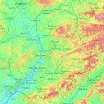
Name: Zlín Region topographic map, elevation, terrain.
Location: Zlín Region, Central Moravia, Czechia (48.85413 17.10970 49.53977 18.41557)
Average elevation: 1,168 ft
Minimum elevation: 502 ft
Maximum elevation: 3,629 ft
Make a donation
Gear up for your next adventure:
As an Amazon Associate, this site earns from qualifying purchases at no extra cost to you.
Other topographic maps
Click on a map to view its topography, its elevation and its terrain.
Make a donation
Gear up for your next adventure:
As an Amazon Associate, this site earns from qualifying purchases at no extra cost to you.
Loučná nad Desnou
Czechia > Central Moravia > Olomouc Region > Loučná nad Desnou > Loučná nad Desnou
Average elevation: 2,008 ft