
Make a donation
Gear up for your next adventure:
As an Amazon Associate, this site earns from qualifying purchases at no extra cost to you.
Pirmasens topographic map
Click on the map to display elevation.
Make a donation
Gear up for your next adventure:
As an Amazon Associate, this site earns from qualifying purchases at no extra cost to you.
Pirmasens
Pirmasens liegt am südwestlichen Rand des Pfälzerwalds im Nordwesten des Wasgaus, wie der Südteil des Pfälzerwalds und der sich anschließende Nordteil der Vogesen auch genannt wird. Die mittlere Höhe der hügeligen Kernstadt beträgt 387 m. Im Westen liegen die kreisfreie Stadt Zweibrücken und der Saarpfalz-Kreis, im Norden die Landkreise Kusel und Kaiserslautern, im Nordosten der Landkreis Bad Dürkheim, im Osten der Landkreis Südliche Weinstraße und im Süden die Staatsgrenze zu Frankreich mit den Départements Moselle und Bas-Rhin. Nachbargemeinden sind – im Uhrzeigersinn – Rodalben, Münchweiler an der Rodalb, Lemberg, Obersimten, Vinningen, Bottenbach, Nünschweiler, Höheischweiler und Petersberg.
Make a donation
Gear up for your next adventure:
As an Amazon Associate, this site earns from qualifying purchases at no extra cost to you.
About this map
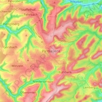
Name: Pirmasens topographic map, elevation, terrain.
Location: Pirmasens, Rheinland-Pfalz, 66953, Deutschland (49.15970 7.56878 49.23970 7.64878)
Average elevation: 1,184 ft
Minimum elevation: 837 ft
Maximum elevation: 1,470 ft
Make a donation
Gear up for your next adventure:
As an Amazon Associate, this site earns from qualifying purchases at no extra cost to you.